
Cumbria is a county in North West England, shaped by mountains, lakes, coastline, and a scattered pattern of market towns and industrial settlements. It was created in 1974 under the Local Government Act 1972, bringing together historic areas that had previously been administered separately. Carlisle is its county town and largest settlement, while Barrow-in-Furness is the other major urban centre.
Stories from Cumbria
1 story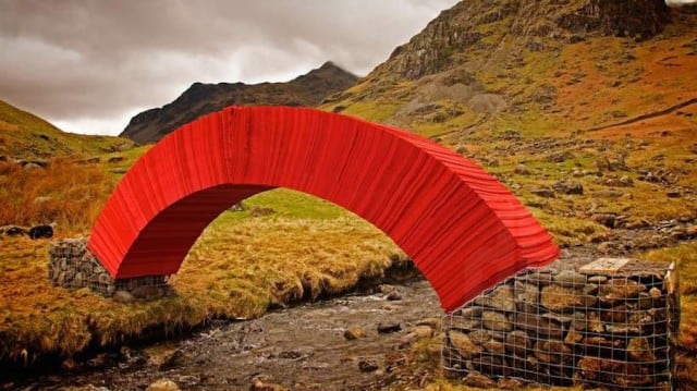
About Cumbria
| Fact | Detail |
|---|---|
| Type | Non-metropolitan county |
| Region | North West England |
| Created | 1974 |
| County town | Carlisle |
| Largest town | Carlisle |
| Other major urban area | Barrow-in-Furness |
Read the full overviewHow Cumbria was formed, What does Cumbria look like on the ground?, Why does Cumbria matter?, How is Cumbria used in art and design projects?
How Cumbria was formed
Cumbria is a relatively recent administrative county, even though the land itself has a much older identity. Before 1974, the area was split between Cumberland, Westmorland, parts of Lancashire north of the Sands, and a small section of Yorkshire. The reorganisation created one county authority with responsibility for roads, schools, planning, and other local services across a large and varied territory.
That administrative history matters because the name “Cumbria” now describes both a modern local government area and a broader cultural landscape. In practice, the county has had to manage very different places under one umbrella: the urban edge of Carlisle, the shipbuilding town of Barrow, agricultural valleys, upland fells, and the Lake District. Those contrasts shape how the county is understood and represented.
What does Cumbria look like on the ground?
Cumbria is one of England’s least densely populated counties, and much of its character comes from distance and scale. The Lake District dominates the centre and south, with high ground, glacial valleys, and bodies of water that have long influenced settlement, transport, and tourism. Away from the lakes, the county opens into pastoral lowlands, estuaries, and industrial coastlines.
Carlisle sits near the Scottish border and has long served as an administrative and commercial centre. Barrow-in-Furness, on the south-western peninsula, developed around shipbuilding and heavy industry, giving the county a second focal point that is very different in character from Carlisle. Between those poles lie smaller towns, villages, and dispersed rural communities linked by roads that often follow older routes through difficult terrain.
Why does Cumbria matter?
Cumbria matters because it concentrates several strands of English history in one place: border defence, rural land use, industrial manufacture, and landscape preservation. The county includes some of the country’s best-known scenery, but it is not only a scenic region. It is also a working landscape, with farming, quarrying, engineering, port activity, and tourism all leaving visible marks.
For visual culture, Cumbria often appears as a site where interventions in the landscape become legible at large scale. Public art, architecture, and temporary projects can read differently here because the county’s spaces are so open and its materials so grounded in local conditions. A work made in Cumbria is often in dialogue with stone, slate, paper, weather, and distance, not just with the built environment.
How is Cumbria used in art and design projects?
Cumbria is frequently chosen for projects that need room, weather, or a strong relationship to place. Artists and designers working there often draw on local materials such as stone, slate, timber, and paper, or on the county’s industrial and rural histories. The setting can give a temporary work a specific physical authority, especially when the piece responds to topography or uses the landscape as a frame.
That is part of why Cumbria appears in projects like Steve Messam’s large-scale paper bridge. The county’s environment makes scale visible: a structure or installation has to contend with open views, variable weather, and a landscape that can make even a bright, temporary object feel both exposed and exact. In that sense, Cumbria is not just a location but an active condition of making.
Frequently Asked Questions
Is Cumbria the same as the Lake District?
No. The Lake District is a part of Cumbria, not the whole county. Cumbria also includes Carlisle, Barrow-in-Furness, coastal areas, valleys, and farmland.
Why is Carlisle important to Cumbria?
Carlisle is the county town and largest settlement, so it serves as Cumbria’s main administrative centre. Its position near the border has also given it long-standing strategic importance. That has helped make it the county’s most prominent urban hub.
Why do artists and designers work in Cumbria?
Cumbria offers strong natural forms, a distinct material culture, and places where large-scale work can be seen at distance. Its stone, slate, weather, and open terrain often become part of the work rather than just the backdrop. That makes it useful for projects that need a clear relationship between object and site.