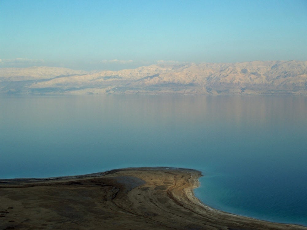
The Dead Sea is a hypersaline lake on the border between Jordan and Israel and the West Bank, and it sits at Earth’s lowest land elevation. Its water is so dense with dissolved minerals and salt that people float almost effortlessly, while the lake’s margins and surrounding mud leave visible white crusts and crystalline deposits.
- Type: salt lake, also called the Salt Sea
- Location: Jordan to the east; Israel and the West Bank to the west
- Elevation: about 423 metres below sea level
- Depth: around 377 metres
- Notable for: extreme salinity, buoyancy, mineral-rich mud, and salt formations
Why is the Dead Sea so unusual?
The Dead Sea is not a sea in the open-ocean sense. It is a closed basin, meaning water flows in but does not flow out to the ocean. Rivers and groundwater bring in dissolved minerals, but under the region’s hot, dry conditions, water leaves mainly by evaporation. That process concentrates salts to levels far beyond those of ordinary seawater.
The result is a body of water where most life cannot survive, which explains the name. The lake’s chemistry creates a stark visual character: bright mineral crusts on shore, opaque blue-green water, and dark mud that can dry into a pale, powdery skin.
Where is it and what does the landscape look like?
The Dead Sea sits in the Jordan Rift Valley, a long geological depression formed by tectonic movement. Its surface and surrounding shores lie far below global sea level, making it the lowest exposed land on the planet. Steep desert slopes, eroded cliffs, and sparse vegetation frame the basin, giving it a stripped, mineral landscape that changes sharply with light.
This setting matters to artists and photographers because it reads as both landscape and material field. Salt terraces, shoreline crystals, and the mirror-like water surface create strong textures and high contrast. From a distance, the scene can look almost monochrome; up close, it reveals fine deposits, wet mud, and fractured salt crust.
How does the Dead Sea appear in visual culture?
The Dead Sea often appears in fashion, photography, and environmental imagery because it produces unusual effects on cloth, skin, and surface. Fabrics dragged through the water can stiffen as salt crystallizes on the fibres, turning a garment into a sculptural object. Mud and salt also leave graphic traces that read well in close-up photography.
It is also used as a symbol of fragility. Because the lake is shrinking under pressure from water diversion, extraction, and climate stress, it appears in work about ecological loss and changing landscapes. In that context, the Dead Sea is not only a striking site but also a visual record of environmental decline.
What makes it important beyond its appearance?
The Dead Sea matters geologically, geographically, and culturally. It marks an extreme point in the Earth’s topography and serves as a visible example of how enclosed water systems behave in arid climates. The lake’s minerals have long drawn attention for bathing, skin care, and industrial use, and its shoreline has carried religious and historical significance for centuries.
For FreeYork readers, its value lies in how material conditions shape form. Salt, mud, evaporation, and tectonics all act directly on objects and bodies at the site. That makes the Dead Sea a place where landscape behaves like a process, not just a backdrop.
Frequently Asked Questions
Why is it called the Dead Sea?
The name refers to the fact that the water’s extreme salinity prevents most plants and animals from living in it. Fish and many forms of aquatic life cannot survive in such concentrated brine. The name has been used for centuries, though it is often called the Salt Sea as well.
Can anything live in the Dead Sea?
Most larger life forms cannot, but some salt-tolerant microorganisms do survive in and around it. These microbes adapt to conditions that would kill ordinary marine life. Even so, the lake remains one of the harshest natural aquatic environments on Earth.
Why is the Dead Sea shrinking?
The lake has been losing water for decades because less freshwater reaches it than in the past. Rivers feeding the basin have been diverted, and mineral extraction and evaporation intensify the loss. As water levels fall, shorelines retreat and salt formations expand, changing the visual and physical character of the place.
</json
At a glance
- Address
- Israel, Jordan
- Coordinates
- 31.5, 35.5
Articles mentioning Dead Sea