The Great Plains are a broad interior region of North America, defined by wide grasslands, low relief, and a climate that becomes drier toward the west. They stretch from the Mississippi River basin to the foothills of the Rocky Mountains, crossing much of the central United States and parts of southern Canada.
- A vast physiographic region rather than a single political boundary.
- Includes prairie, steppe, and mixed-grass ecosystems shaped by wind, drought, fire, and grazing.
- Spans parts of ten U.S. states and three Canadian provinces.
- Known for open horizons, large-scale agriculture, and a built environment adapted to extreme weather.
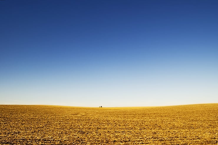
- Its visual identity often comes from emptiness, distance, and the meeting of sky and land.
What are the Great Plains?
The Great Plains form one of North America’s defining landscapes. They are not perfectly flat, but their terrain is gentle enough that distance and sky dominate the view. In the eastern sections, rainfall supports tallgrass prairie; farther west, conditions shift toward shortgrass prairie and steppe. The region includes the U.S. states of Colorado, Kansas, Montana, Nebraska, New Mexico, North Dakota, Oklahoma, South Dakota, Texas, and Wyoming, along with Alberta, Manitoba, and Saskatchewan in Canada.
Geographers use the term for a large natural region, but the name also carries cultural weight. It suggests frontier history, agricultural production, Indigenous homelands, and a style of life organized around land, weather, and scale. In visual culture, the Great Plains often appear as a setting where structures must answer to openness rather than enclosure.
Why do the Great Plains matter?
The Great Plains matter because they are both a working landscape and a visual one. Their soils support wheat, corn, cattle, and oil extraction; their towns, farms, grain elevators, and roads reveal how design follows utility across long distances. Architecture in the region often responds to heat, cold, strong wind, and severe storms, producing forms that are compact, sheltered, and durable.
The region also matters historically. It was home to many Indigenous nations long before Euro-American settlement, and later became central to westward expansion, rail transport, and industrial agriculture. Any account of the Great Plains has to hold those layers together: ecology, labor, settlement, and displacement.
What does the Great Plains landscape look like in practice?
In practice, the Great Plains are marked by horizon lines, open fields, low vegetation, and long sightlines. Tree cover is sparse in many areas, so buildings and infrastructure stand out clearly against the land and sky. That clarity has made the region a powerful subject for photography, painting, film, and architecture, where small changes in light or weather can transform the whole scene.
The landscape is not uniform. River valleys, badlands, dunes, escarpments, and sheltered breaks interrupt the broad flatness. Prairie grasses, seasonal burns, snow cover, and shifting cloud formations give the region texture over time. In design terms, the Great Plains are less a backdrop than a set of conditions: exposure, repetition, and the need to build for endurance.
How have makers and designers used the Great Plains?
Designers working in or about the Great Plains often take cues from climate and material scarcity. Wood, brick, metal siding, concrete, and local stone recur in buildings that need to withstand weather and remain economical over large spans of land. Agricultural structures such as barns, silos, and grain elevators became some of the region’s most recognisable forms, turning storage and transport into an accidental architecture of modernity.
Artists and architects have also used the Plains as a way to think about scale. A house, museum, or installation placed in this landscape cannot ignore distance, light, and the surrounding emptiness. That is part of what gives the region force in visual culture: it makes form legible, but also makes fragility visible.
Frequently Asked Questions
Are the Great Plains the same as the Midwest?
No. The Great Plains overlap with some Midwestern states, but they are defined primarily by ecology and landform, not by cultural region alone. The Midwest usually refers to a broader and more varied part of the United States, while the Great Plains describe a specific grassland belt extending farther west. The two terms can intersect, but they are not interchangeable.
Why are the Great Plains often described as flat?
They are called flat because the region has very low relief compared with mountain or plateau country, and the land often appears level across long distances. In reality, there are ridges, valleys, escarpments, and other breaks in the terrain. The scale of the region makes those variations feel subtle until weather, light, or elevation reveals them.
What kinds of buildings are associated with the Great Plains?
Farmhouses, barns, grain elevators, sheds, churches, and small civic buildings are strongly associated with the region. Their forms usually answer practical needs: shelter from wind, efficient storage, and economical construction. Even contemporary architecture in the Great Plains often keeps that emphasis on durability and clear structure.
At a glance
- Address
- Thomas County, United States
- Coordinates
- 37, -97
Articles mentioning Great Plains