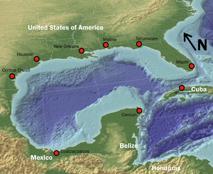
The Gulf of Mexico is a large ocean basin bordered by the United States, Mexico, and Cuba. It forms a warm, semi-enclosed body of water connected to the Atlantic through the Florida Straits and to the Caribbean through the Yucatán Channel. In coastal culture and industry, it often appears as the “Third Coast,” a name used especially in Texas and Louisiana.
- Type: Ocean basin / marginal sea
- Location: Between the U.S. Gulf Coast, eastern Mexico, and western Cuba
- Connections: Atlantic Ocean via the Florida Straits; Caribbean Sea via the Yucatán Channel
- Common regional name: The Third Coast
- Why it matters: Major shipping route, fishing ground, energy zone, and site of hurricanes and environmental risk
What is the Gulf of Mexico?
The Gulf of Mexico is not a single coastline but a vast inland sea framed by three countries. Its waters circulate slowly in a broad loop, bringing warm temperatures, nutrient flows, and powerful storm systems that shape the region around it. Because it sits between continents and trade routes, it has long been treated as both a natural feature and an economic corridor.
The gulf’s shape matters. Its enclosed form concentrates shipping lanes, fisheries, offshore drilling platforms, and coastal cities along its rim. At the same time, that same enclosure makes pollution, oil spills, and storm damage harder to disperse. For this reason, the gulf is never just background scenery; it is an active environment that affects settlement, design, logistics, and extraction.
Why is it called the “Third Coast”?
“Third Coast” is a regional nickname for the U.S. shoreline along the Gulf of Mexico, especially in Texas and Louisiana. The phrase places the gulf alongside the Atlantic and Pacific coasts as a distinct American maritime edge with its own culture, industry, and visual identity. It also signals a different rhythm of coast: marshes, estuaries, ports, oil infrastructure, hurricane exposure, and long flat horizons.
That coastal identity has influenced architecture and urban planning. Port cities, barrier-island settlements, and waterfront districts in the region often respond to flood risk, humidity, wind, and salt air rather than to the cliffed or rocky conditions seen elsewhere. In practical terms, the “Third Coast” is a built environment shaped by water management as much as by leisure or scenery.
What does the Gulf look like in practice?
In photographs and maps, the Gulf of Mexico often appears as a broad blue-green expanse with pale coastal shelves, marshes, deltas, and barrier islands around its edges. The Mississippi River Delta, the Yucatán coast, and the Cuban shoreline each give it a different visual character, but all show the same mix of land and water. Its surface can shift from calm and luminous to violently textured under tropical storms and hurricanes.
In human use, the gulf is equally mixed. Fishing fleets, container ports, cruise terminals, offshore rigs, and coastal resorts occupy the same waters or nearby shorelines. That overlap makes it a useful reference point in design and documentary work because it reveals how infrastructure, labor, consumption, and climate all meet at one edge of the continent.
Why does the Gulf of Mexico matter?
The gulf matters because it concentrates economic activity and ecological vulnerability in one region. It supports major commercial fisheries, oil and gas extraction, global shipping, and a dense chain of coastal communities. It also sits in the path of Atlantic hurricanes, which means its shoreline is repeatedly tested by wind, surge, flooding, and erosion.
For visual culture, the gulf often stands in for systems that are usually hidden: maritime trade, container loss, offshore extraction, climate damage, and cross-border circulation. Images from the region can show luxury development beside industrial ports, or ordinary household goods lost at sea beside vast weather systems. That contrast is part of what makes the gulf a recurring subject in contemporary reporting and photography.
Frequently Asked Questions
Is the Gulf of Mexico an ocean or a sea?
It is usually described as a marginal sea or ocean basin rather than a full ocean. It is connected to the Atlantic Ocean and the Caribbean Sea, but it is partly enclosed by land. The term used depends on context, geography, and tradition.
Which countries border the Gulf of Mexico?
The Gulf of Mexico is bordered by the United States to the north, Mexico to the west and south, and Cuba to the southeast. Those borders give it a tri-national character that matters in shipping, fishing, environmental regulation, and disaster response. Its coastline is shared by many different regional economies and cultures.
Why do artists and journalists return to the Gulf of Mexico?
They return to it because the gulf makes large-scale systems visible. Trade, extraction, storms, migration, and ecological stress all become legible along its shores and in its waters. That combination gives it strong visual and documentary power.
At a glance
- Address
- Mexico
- Coordinates
- 25, -90
Articles mentioning Gulf of Mexico