
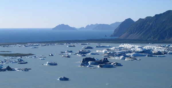
Kenai Fjords National Park is a United States national park on the Kenai Peninsula in southcentral Alaska, known for its tidewater glaciers, fjords, and the Harding Icefield.
| Type | National park |
|---|---|
| Location | Kenai Peninsula, southcentral Alaska, near Seward |
| Established | 1980 |
| Area | 669,984 acres |
| Named for | The fjords carved by glaciers descending from the icefield |
What makes Kenai Fjords National Park distinctive?
The park combines coastal scenery with active glacial landscape. The Harding Icefield feeds outlet glaciers that move down steep mountainsides into deep water, creating the fjords that give the park its name. That meeting of ice, rock, forest, and sea makes the park visually compressed and dramatic: blue ice fronts, dark water, mist, and steep green slopes often appear in the same frame.
Unlike a park defined mainly by trails or roads, Kenai Fjords is shaped by moving ice and changing shoreline. Much of its character comes from what is happening now: calving glaciers, tide shifts, weather, and seasonal light. That makes it a place where landscape photography and field observation both matter, because the scene changes minute by minute.
How was it established?
Kenai Fjords National Park was created in 1980 under the Alaska National Interest Lands Conservation Act, the major federal law that expanded protected lands across Alaska. The designation protected a large coastal wilderness that had long been recognized for its glacial features and ecological value. Its establishment reflected a broader effort to preserve Alaska’s large, relatively intact landscapes before development and extraction could alter them more heavily.
The park’s protected status matters because glaciers, marine habitat, and mountain terrain form a connected system. Protecting only the icefield would not preserve the fjords below it, and protecting only the coastline would miss the source of the glaciers themselves. The park’s boundary captures that relationship between high ice and low sea.
What does the landscape look like in practice?
Kenai Fjords is not a single visual experience but a set of linked environments. The Harding Icefield sits high above the coast as a broad expanse of ice, while outlet glaciers descend through valleys toward the Gulf of Alaska. Along the shoreline, narrow inlets and steep walls create the fjord landscape, and islands and marine waters add another layer of texture and movement.
In practice, the park is often experienced by boat, plane, or on foot from the edge of its icefield and trails. The scale is large, but the details are specific: crevasses in the ice, striations on rock, floating ice, and the color shifts of water under changing weather. For artists, photographers, and designers interested in natural form, it offers a clear lesson in how erosion, freeze-thaw, and time shape structure.
Why does it matter?
The park matters as both a conservation area and a record of glacial geology. It protects a rare combination of icefield, coastal rainforest, fjord, and marine habitat in one unit. That combination supports wildlife and also preserves a landscape still visibly being made and remade by climate, tide, and glacier movement.
For visual culture, Kenai Fjords is important because it presents scale with unusual force. The scenery is not decorative; it is physical evidence of geologic process. The park has become one of the most recognizable expressions of Alaska’s glacial coast, and its images often stand in for the state’s larger identity of ice, weather, and remoteness.
Frequently Asked Questions
Is Kenai Fjords National Park mainly about glaciers?
Glaciers are central to the park, but they are not the whole subject. The fjords, mountain slopes, marine waters, and wildlife all belong to the same landscape system. The icefield explains the shape of the coast, yet the park’s character also depends on salt water, storm conditions, and vegetation along the lower elevations.
Can the park be understood without visiting it?
The park can be understood through photographs, maps, and descriptions of glacial landforms, but direct experience adds important scale and movement. The size of the icefield and the steepness of the fjords are easier to grasp in person or from aerial and marine viewpoints. Images capture the forms; they cannot fully convey the weather, sound, and shifting light.
Why is the Harding Icefield important?
The Harding Icefield is the source of many of the park’s glaciers and the engine behind its fjord landscape. It is one of the largest icefields in the United States, and its mass feeds the slow movement of ice down toward the coast. Without it, Kenai Fjords would lose the geological process that gives the park its name and much of its visual identity.
At a glance
- Address
- Kenai Peninsula Borough, United States
- Coordinates
- 59.917778, -149.9875
Articles mentioning Kenai Fjords National Park
