
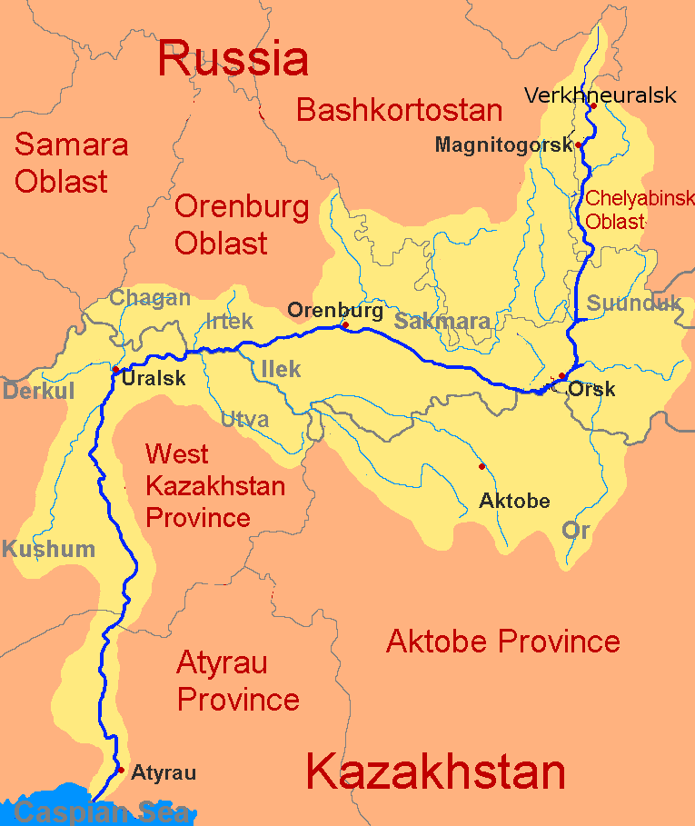
The Ural River is a major river in Russia and Kazakhstan that flows south from the southern Ural Mountains to the Caspian Sea. It was known as the Yaik until 1775, and it is also called Jayıq or Zhayyq in local usage. At 2,428 kilometres long, it is the third longest river in Europe after the Volga and the Danube, and one of the two great rivers that feed the Caspian basin.
- It begins in the southern Ural Mountains and empties into the Caspian Sea.
- Its length is about 2,428 kilometres, or 1,511 miles.
- It crosses or borders both Russia and Kazakhstan.
- Historically it was called the Yaik, a name changed in 1775.
- It is one of the Caspian Sea’s main tributaries alongside the Volga.
Where does the Ural River run?
The Ural rises in the southern Ural Mountains, then moves generally south through a broad steppe landscape before reaching the Caspian Sea. Its course marks a large environmental corridor between forested uplands and dry lowlands, and it has long shaped settlement, transport, and agriculture along its banks. Rivers in this part of Eurasia do not simply cut through terrain; they organise it, creating routes, boundaries, and productive floodplains.
The river passes through two countries, Russia and Kazakhstan, which gives it political as well as geographic weight. In the lower reaches, the river slows and spreads across flatter land before forming a delta-like outlet into the Caspian. That combination of mountain source, long continental run, and terminal sea makes the Ural a classic large river system rather than a short regional watercourse.
Why does the Ural River matter?
The Ural matters first as one of Europe’s longest rivers and as a principal feeder of the Caspian Sea. Along with the Volga, it helps sustain the hydrology of the world’s largest inland sea, affecting water levels, sediment movement, and the ecology of the Caspian basin. For inland cultures and economies, such rivers are not background features; they are infrastructure before infrastructure, carrying water, fish, flood deposits, and movement.
It also matters historically because names attached to rivers often carry political force. The older name, Yaik, was replaced in 1775, which signals more than a simple change in labeling. River names can be tied to state control, regional identity, and the writing of official geography, so the Ural’s nomenclature tells part of the story of imperial and post-imperial Central Eurasia.
What does a river like this look like in practice?
On the ground, the Ural is not a single uniform channel. It changes character as it moves from mountain-fed upper reaches to broader plains and wetlands downstream. In the upper course, the river tends to be narrower and more energetic; farther south, it becomes slower, wider, and more suited to floodplain use, with seasonal variation shaping how people cross, farm, and build nearby.
For artists, designers, and mapmakers, the Ural is the kind of river that reads as both line and system. It functions as a boundary on maps, a corridor for transport and migration, and a source of local material life through fishing, irrigation, and riverside settlement. Its scale and dual identity as border and artery make it a useful reference when discussing landscape, territory, and the visual language of place.
How is it different from the Volga or other major rivers?
The Ural is often compared to the Volga because both drain into the Caspian Sea, but they play different roles. The Volga is longer and more central to Russian history, while the Ural is more of a frontier river, running across a wide transitional zone between Europe and Asia. That position gives it a distinct cultural meaning: less imperial centre, more edge and passage.
It also differs from rivers that are heavily urbanised or engineered. The Ural’s significance has come more from geography than from monumental riverfront development. Its value lies in extent, location, and basin function, not in being a famous city river with a dense built edge.
Frequently Asked Questions
Why was the name changed from Yaik to Ural?
The name changed in 1775 as part of a political response to unrest associated with the region. Changing a river’s name is an administrative act, but it also reshapes memory, since waterways often anchor local identity more strongly than towns or districts. The older name survives in historical references, while the newer one reflects the official geography of the Russian Empire and its successors.
Is the Ural River really in Europe?
Yes, the Ural is generally counted among Europe’s longest rivers, though it flows through a continental border zone where Europe and Asia meet. Its classification depends on the convention used for the Europe-Asia divide, but standard geographic references place its source and much of its course within the European side of that divide. That is why it is usually listed after the Volga and the Danube in European river rankings.
What kind of landscape does the river pass through?
The river begins in the southern Ural Mountains and then moves into open steppe and lowland terrain. This produces a broad transition from upland watershed to flatter, drier country with floodplains near the lower course. The changing landscape helps explain why the river has mattered for travel, settlement, and agriculture over a long distance.
At a glance
- Address
- Bashkortostan, Kazakhstan
- Coordinates
- 46.883335, 51.616665