
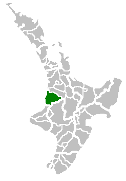
Waitomo District is a rural territorial authority in the north of New Zealand’s King Country, on the North Island. It is best known for farming land, limestone landscapes, and the Te Kuiti seat of the Waitomo District Council. Most of the district sits in the Waikato region, although a small part around Tiroa lies in Manawatū-Whanganui.
| Fact | Detail |
|---|---|
| Country | New Zealand |
| Region | Mainly Waikato; small part in Manawatū-Whanganui |
| District seat | Te Kuiti |
| Character | Rural, predominantly dairy farming |
| Key settlement | Te Kuiti, population 4,419 |
Where is Waitomo District?
Waitomo District occupies a broad inland area south of Hamilton and west of the central North Island plateau. It forms part of the King Country, a region shaped by steep country, river valleys, and a sparse settlement pattern. The district’s main town, Te Kuiti, acts as the administrative and service centre, while most other settlements remain small.
The district boundaries do not align perfectly with regional lines. That matters because Waitomo is administered as one territorial authority, but a small area including Tiroa falls under a different regional authority. This kind of boundary overlap is common in New Zealand local government and can affect planning, transport, and environmental management.
What kind of place is it?
Waitomo is a working rural district rather than an urban one. Dairy farming dominates much of the land use, and the landscape is organised around pasture, fencing, roads, sheds, and drainage rather than dense town centres. The low population outside Te Kuiti gives the district a dispersed, agrarian character.
Te Kuiti, with a population of 4,419, is by far the largest settlement in the district and the location of the council offices. Elsewhere, villages are small, and no other settlement exceeds 500 people. That makes the district’s identity depend less on a chain of towns and more on the relationship between a central service town and a large rural hinterland.
Why is Waitomo District known?
The district is closely associated with the Waitomo cave country, one of New Zealand’s best-known natural attractions, even though much of the district is farmland. Limestone geology underpins that reputation: underground drainage, cave systems, and eroded rock formations create the conditions for the glowworm caves and related visitor sites.
That natural fame sits alongside a more ordinary local economy based on agriculture. The contrast is part of the district’s significance: it combines globally recognisable tourist landscapes with the practical infrastructure of a farming district. For design and visual culture, that means Waitomo often appears as both destination and working landscape, with scenery shaped by geology and by rural production.
How is it experienced on the ground?
In practice, Waitomo District is a place of long distances, modest town centres, and open land. Roads connect farms, caves, and small settlements through rolling country. Te Kuiti provides the main civic functions, while the surrounding district is defined by sheds, milking infrastructure, local halls, schools, and service stops rather than heavy commercial development.
The visual character of the district changes sharply between tourist sites and everyday rural spaces. Cave entrances, limestone cliffs, and native bush attract visitors, but the day-to-day built environment is plain and functional. That contrast is important: Waitomo is not a single landscape type, but a district where spectacle and routine farming coexist.
Frequently Asked Questions
Is Waitomo District the same as the Waitomo Caves?
No. The district is a local government area, while the caves are one of several natural attractions within and around it. The name overlaps because the caves helped make the district internationally familiar.
What is the main town in Waitomo District?
Te Kuiti is the district seat and the main town. It houses the district council and provides most of the services for the surrounding rural area. No other village in the district is comparable in size.
Why does Waitomo matter beyond tourism?
Waitomo matters as a working rural district with a strong agricultural base. Its landscape shows how farming, geology, and local administration shape place at the same time. The district is also a useful example of how a globally known attraction can sit inside a much larger everyday territory.