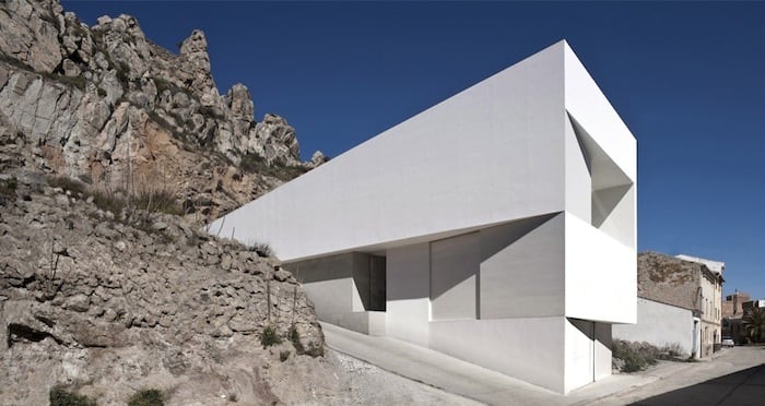
Ayora is a municipality in the Valle de Cofrentes comarca of the Valencian Community in inland Spain, close to the provincial borders with Albacete and Alicante. It sits in the Valley of Ayora, a broad mountain basin shaped by the Sierra Palomera and Mugrón to the west and by Cortes de Pallás and the Caroig massif to the east. Its territory is defined less by a single townscape than by a landscape of valleys, forests and mountain tracks.
- Location: Inland Valencian Community, near the border with Castilla-La Mancha and the province of Alicante
- Administrative status: Municipality
- Comarca: Valle de Cofrentes
- Landscape: Mountain valleys, forest routes, slopes and rocky ridges
- Built context: Rural settlements and hillside architecture adapted to steep terrain
Where is Ayora, and what kind of place is it?
Ayora belongs to the interior of the Valencian Community rather than its coastal belt, and that location shapes almost everything about it. The municipality lies in a corridor of hills and valleys where movement follows the contours of the land, not a flat grid. Roads, tracks and settlements adapt to a terrain that is dry, elevated and broken by mountain ridges.
That setting makes Ayora feel distinct from the Mediterranean image many people associate with Valencia. Instead of beaches and port cities, the area is known for slopes, forested uplands and long views across inland country. For architecture and landscape reading, that matters: buildings here respond to height, exposure and irregular ground.
What does the Valley of Ayora look like?
The Valley of Ayora stretches between two mountain systems, with the Sierra Palomera and Mugrón on one side and the high ground around Cortes de Pallás and the Caroig peak on the other. The result is a wide inland basin with a strong edge. Forest tracks cut across the valleys, and the mountains close the horizon rather than opening it.
This is a landscape of transitions. Gentle valley floors give way quickly to steep slopes, while woodland and scrub alternate with more open ground. In practical terms, that means construction, farming and movement all have to reckon with incline, drainage and access. The area’s geography is not a backdrop; it is the main condition that shapes how the place is used.
Why does Ayora matter in architecture and design?
Ayora matters because landscape is not an abstract idea there. It is a structural fact that affects settlement patterns, materials and building form. Rural architecture in places like this often works with local stone, compact volumes and careful placement on sloping ground, because heavy visual gestures are less convincing than structures that sit naturally within the terrain.
The municipality also appears in contemporary architectural projects that use the mountain setting as part of the design brief. In houses and retreats built on the hillside, the response to topography, sun, views and privacy becomes as important as the plan itself. Ayora is therefore useful as a reference point for projects that treat site conditions as a generator of form rather than a problem to hide.
How is Ayora used as a site in contemporary work?
In contemporary residential work, Ayora often stands for a specific kind of inland Mediterranean site: remote enough to demand self-sufficiency, but still shaped by local settlement and agricultural history. Architects working there typically need to address access roads, slope stability, exposure to wind and sun, and the relationship between a building and the surrounding mountain profile.
That produces architecture with a strong sense of orientation. Openings often frame distant views; terraces and retaining walls negotiate level changes; materials tend to be chosen for durability and visual calm. In this context, Ayora is not just a name on a map. It describes a physical setting that directly influences how a project is drawn, constructed and inhabited.
Frequently Asked Questions
Is Ayora a town or a region?
Ayora is a municipality, which means it is a local administrative area centered on a town and its surrounding territory. It is also part of a broader comarca, the Valle de Cofrentes. In everyday reference, the name can point to both the town itself and the municipality around it.
What kind of landscape surrounds Ayora?
Ayora sits in a valley framed by mountain ranges, with forest tracks, ridges and slopes defining the area. The terrain is inland and elevated, not coastal, and it has a strongly rural character. That combination makes the landscape important in both daily life and architectural response.
Why would a design publication mention Ayora?
Design publications mention Ayora when a project depends on its topography, light or isolated mountain setting. A house or landscape intervention there has to address steep ground, long views and the practical limits of building in a rural valley. The place is significant because it shapes form, not because it is famous as a destination.
At a glance
- Coordinates
- 39.058334, -1.057222
Articles mentioning Ayora