
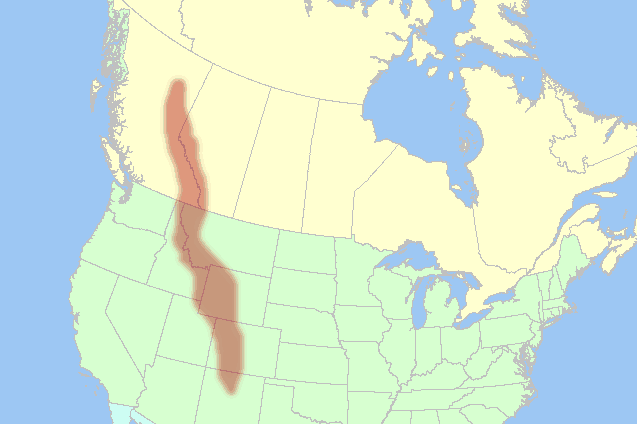
The Rocky Mountains are a major mountain range in western North America, running from northern British Columbia and Alberta down through the United States to New Mexico. Commonly called the Rockies, they form one of the continent’s defining landscapes: a long spine of high peaks, broad valleys, alpine tundra, conifer forests, and river headwaters that feed much of the West.
| Type | Mountain range |
|---|---|
| Region | Western North America |
| Also called | The Rockies |
| Approximate length | More than 3,000 miles |
| Countries | Canada and the United States |
Where are the Rocky Mountains?
The Rockies extend from the far north of British Columbia and Alberta through Montana, Idaho, Wyoming, Colorado, and New Mexico. They belong to the broader North American Cordillera, a chain of mountain systems along the western side of the continent, but they sit east of the Pacific Coast Ranges, the Cascade Range, and the Sierra Nevada. That position gives them a distinct geological and ecological identity, with dry inland basins on one side and mountain-fed watersheds on the other.
Geographers usually treat the Rockies as a long, varied system rather than a single uniform crest. Some sections are heavily glaciated and sharply alpine, while others break into rounded plateaus, narrow passes, and broad foothills. The range includes many national parks, protected areas, ski regions, and wilderness zones, which is one reason it appears so often in landscape photography and environmental art.
How were they formed?
The Rocky Mountains rose during a long period of tectonic activity that lifted and folded the crust of western North America. Much of their present shape dates to the Laramide orogeny, a mountain-building episode that began roughly 80 million years ago and continued into the early Cenozoic. Older rocks were pushed upward, faulted, and eroded into the ridges and basins visible today.
That deep geological history matters because it shapes what can be seen at the surface: exposed sedimentary layers, granite intrusions, steep cirques, moraines, and alpine lakes. In practical terms, the range is not just “mountains” as scenery. It is a record of tectonic uplift, ice age erosion, and ongoing weathering, all of which determine the textures that artists and photographers find there.
Why do the Rockies matter visually and culturally?
The Rockies have long occupied a powerful place in North American visual culture. Their scale makes them a standard reference for wilderness, distance, and ecological abundance, but their meaning also depends on who is looking. Indigenous nations have lived in and around these mountains for millennia, and the range remains central to many cultural geographies, not merely to recreation or tourism.
For artists, the Rockies offer a dense field of motifs: layered ridgelines, snowline contrasts, storms moving across high passes, and seasonal shifts in forest color. For photographers, the range provides strong atmospheric conditions and a legible sense of depth. For makers working with paper, print, textile, or mixed media, the Rockies often stand in for habitat, scale, and biodiversity, especially in work concerned with conservation and native species.
What do the Rocky Mountains look like in practice?
On the ground, the Rockies can feel like many different environments at once. At lower elevations, lodgepole pine, spruce, fir, and aspen dominate; higher up, trees thin out into subalpine meadows and exposed rock. Snow can persist well into summer on shaded slopes, while river valleys may hold dry grassland or sagebrush. That variety gives the range a strong seasonal rhythm and a wide palette of surfaces, colors, and forms.
In visual work, those details often become shorthand. A craggy summit may suggest endurance; a dense forest valley may suggest shelter; a wide sweep of ridge and sky may suggest remoteness. The Rockies are therefore both a specific place and a flexible image language, used to describe ecological richness, geological time, and the aesthetics of scale.
Frequently Asked Questions
Are the Rocky Mountains and the Rockies the same thing?
Yes. “The Rockies” is the common shortened name for the Rocky Mountains. Both terms refer to the same mountain system in western North America.
Are the Rockies only in the United States?
No. The range begins in Canada and continues into the United States. Its northern sections lie in British Columbia and Alberta, then it stretches south through several U.S. states to New Mexico.
Why do artists and photographers return to the Rockies so often?
The Rockies combine dramatic landforms with strong natural light, visible weather, and marked seasonal change. That makes them useful for work about landscape, biodiversity, and the tension between vastness and detail. They also carry cultural weight as a symbol of wilderness, which gives images of the range an immediate visual charge.