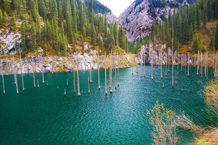
The Tian Shan is a vast mountain system in Central Asia, stretching across Kazakhstan, Kyrgyzstan, Uzbekistan, Tajikistan and western China. Its name means “Heavenly Mountains” in several local languages, and its highest peak, Victory Peak, rises to 7,439 metres. The range shapes climate, water supply and travel across the region, and its high valleys, glaciers and alpine forests have long supported pastoral life, mining and cross-border exchange.
| Fact | Detail |
|---|---|
| Type | Mountain system |
| Region | Central Asia |
| Highest peak | Victory Peak (Jengish Chokusu), 7,439 m |
| Local names | 天山, Хан Тәңірі, ТЕҢИРИ-ТОО, Тэнгэр уул, تەڭرى تاغ |
| Known for | Glaciers, alpine pasture, forests, and major river headwaters |
What makes the Tian Shan important?
The Tian Shan matters because it is one of the major mountain systems of inner Asia, and one of the region’s most visible climate engines. Snow and ice stored in its upper reaches feed rivers that people rely on for farming, grazing, and towns across lowland plains and desert margins. The mountains also create sharp ecological zones: dry foothills, conifer forests, alpine meadows, permanent ice, and bare rock can all appear within a relatively short span.
This diversity has made the range ecologically important and culturally loaded. The mountains appear in Turkic, Kazakh, Kyrgyz, Mongolian and Chinese naming traditions, which reflect how many communities have lived with and crossed them. The range is not a single ridge but a system of chains and basins, so it works less like a wall than a high, segmented landscape that directs movement and settlement.
Where is the Tian Shan, and what does it look like?
The Tian Shan runs through a broad belt of Central Asia, with major sections in Kazakhstan and Kyrgyzstan and extensions into Xinjiang in western China, plus smaller parts in Uzbekistan and Tajikistan. The terrain changes quickly: broad steppe and semi-desert give way to steep valleys, glacier-fed rivers, and serrated peaks. On the ground, the range reads as a sequence of high ridges rather than one continuous skyline, with long passes and enclosed basins between them.
Its appearance depends on altitude and season. Lower slopes may carry grasses and shrubs used for summer grazing, while higher elevations hold spruce forests and then open alpine ground. Above that come glaciers and exposed rock. In photographs, the Tian Shan often shows a strong contrast between green valley floors and pale, snow-covered summits, which is one reason it has drawn attention from climbers, scientists and landscape photographers.
How have people used the Tian Shan?
For centuries, the Tian Shan has supported mobile pastoralism, especially sheep, goats, horses and cattle moved between winter and summer grazing lands. The mountain valleys provided pasture, water and shelter, while passes linked communities on either side of the range. Caravan routes and later modern roads used these same corridors, so the mountains helped structure trade as well as seasonal herding.
The range has also become important for mining, hydropower and conservation. In the modern period, states have treated the mountains as strategic terrain because they hold water sources and border zones. At the same time, conservation efforts have focused on forests, glaciers and endemic species under pressure from logging, grazing, warming temperatures and infrastructure development.
Why does the Tian Shan appear in studies of landscape and material life?
The Tian Shan is often discussed in terms of geology and climate, but it also shapes how things are made. Alpine forests provide timber, pastures support felt-making and animal-based craft traditions, and river systems make agriculture possible in dry regions downstream. The mountains therefore sit behind a great deal of regional material culture, even when they are not the direct subject of an artwork or object.
They also matter to visual culture because they define a kind of scale. The Tian Shan is often depicted as immense, remote and weather-dominated, but it is also inhabited and worked. That combination—monumental geology, seasonal use, and close human dependence on water and pasture—makes the range more than scenery. It is infrastructure, habitat and boundary at once.
Frequently Asked Questions
Is the Tian Shan the same as the Tien Shan?
Yes. “Tien Shan” is a common transliteration, while “Tian Shan” is the modern pinyin spelling of the same Chinese name. Different local languages also use different names, many of them meaning “Heavenly Mountains” or “Mountains of Tengri.”
What is the highest peak in the Tian Shan?
The highest peak is Victory Peak, also known as Jengish Chokusu. It rises to 7,439 metres and lies on the border area between Kyrgyzstan and China. Khan Tengri is the range’s most famous named peak, but it is lower than Victory Peak.
Why do historians and geographers care about the Tian Shan?
The Tian Shan helps explain how Central Asia works as a connected highland-and-basin region. Its rivers, passes and seasonal pastures have shaped movement, settlement and political borders for a long time. It is also a major site of ecological change, especially as glaciers retreat and water systems come under pressure.
At a glance
- Coordinates
- 42.0375, 80.125278
Articles mentioning Tian Shan