
Victoria Harbour is the natural harbour between Hong Kong Island and the Kowloon Peninsula that gives Hong Kong its deep-water waterfront and much of its visual identity. Sheltered, wide and busy, it has long served as the city’s shipping channel, parade ground for monuments and events, and a line around which the modern skyline was built. Its name appears in both English and Chinese usage as Victoria Harbour or Victoria Harbor, and it remains one of the most recognisable urban waterscapes in East Asia.
Stories from Victoria Harbour
3 stories

About Victoria Harbour
- A natural inlet of the South China Sea between Hong Kong Island and Kowloon.
- Its deep water and protected position made it valuable for colonial-era shipping and trade.
- Reclamation on both shores has repeatedly changed its outline and sparked public debate.
- The harbour shapes Hong Kong’s skyline, ferry routes, promenades and public art installations.
- It is as much a built environment as a natural one, because engineering and reclamation have altered its edges for more than a century.
Read the full overviewWhy Victoria Harbour matters, How was Victoria Harbour formed and altered?, What does it look like in practice?, Why does the harbour keep appearing in visual culture?
Why Victoria Harbour matters
Victoria Harbour mattered first as geography. The channel is naturally deep and sheltered, which made it useful for anchorage, port activity and military control. When the British established Hong Kong as a colony in the nineteenth century, the harbour offered the practical advantage that shaped the city’s early development: ships could dock close to shore, goods could move through the port quickly, and settlements could grow along both sides of the water.
It still matters because the harbour structures how Hong Kong is seen and used. Ferries cross it, public works reshape it, and the skyline is framed by its open water. The harbour is not only scenery; it is part of the city’s infrastructure, economy and civic image. Its edges also mark a tension between land reclamation and preservation, since every extension of the shoreline changes the relationship between water, transit and public space.
How was Victoria Harbour formed and altered?
Victoria Harbour is a natural landform, but its present shape is partly engineered. Over many decades, both Hong Kong Island and Kowloon have been extended outward through reclamation, using fill to create new land for roads, rail lines, commercial towers and waterfront redevelopment. That process has narrowed parts of the harbour and moved the shoreline farther from the original coast.
The visual result is striking. What once read as a broad working harbour now has a tighter, more sculpted edge in many places, with piers, promenades, ferry terminals and transport corridors layered along it. Reclamation has enabled development, but it has also removed public water space and altered views that were once open across the channel. That conflict has made the harbour a recurring subject in planning debates.
What does it look like in practice?
In practical terms, Victoria Harbour is a place of movement and display. Cargo vessels, ferries, tourist boats and service craft share the water, while the shoreline carries roads, subway links, exhibition centres, docks and public walkways. At night, the harbour becomes a stage for light, reflection and spectacle, because the towers on both sides are mirrored in the water and seen from promenades, rooftops and boats.
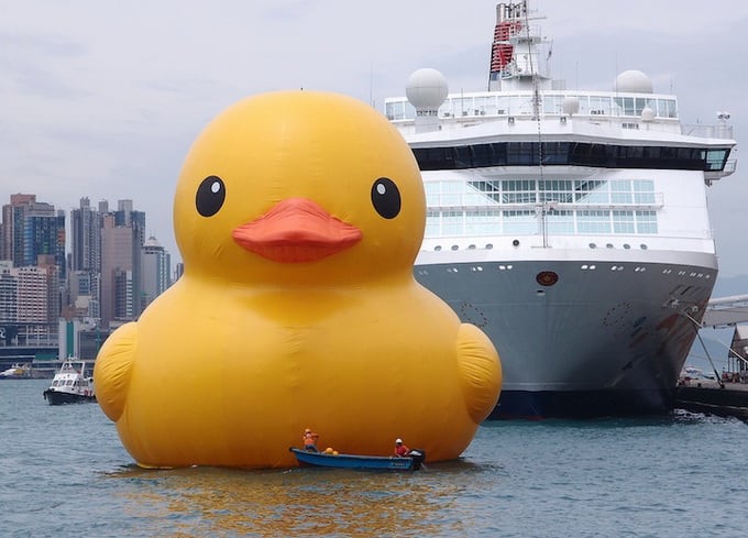
For artists, designers and event makers, the harbour works as a large-scale frame. Inflatable sculptures, illuminated objects and floating installations can read clearly against its open surface and dense skyline. It also provides a strong civic backdrop for model making, animation and architectural image-making, since the harbour instantly situates a scene in Hong Kong even when only a fragment of the waterfront is shown.
Why does the harbour keep appearing in visual culture?
Victoria Harbour appears in visual culture because it compresses many ideas into one view: trade, empire, modern finance, dense urban construction and access to the sea. Its contrast between water and vertical city makes it easy to recognise and hard to mistake. That is why it often appears in tourism images, news coverage, posters, films and public artworks.
It also invites scale play. The harbour can hold tiny objects and enormous interventions at the same time, from toy-like models of junks to temporary works that seem absurdly large against the city. The setting gives those works meaning. A handmade object placed on the harbourfront can read as playful, political or nostalgic because the place already carries so much urban history.
Frequently Asked Questions
Is Victoria Harbour natural or man-made?
It is a natural harbour, shaped by geography and tide rather than excavated from scratch. However, its current outline has been heavily altered by reclamation. Much of the land around it, especially in dense parts of Hong Kong, exists because the shoreline was pushed outward with engineered fill.
Why is the harbour so important to Hong Kong’s history?
Its deep water and sheltered position made it an ideal port. That made it central to colonial administration, maritime trade and later finance and logistics. The city grew around the harbour because ships, goods and people could move through it efficiently.
Why do people argue about reclamation there?
Reclamation creates land for infrastructure and development, but it also reduces open water and changes historic views. In a city where the harbour is part of everyday identity, those changes feel public and permanent. Debates over reclamation usually balance practical needs against the loss of waterfront space and character.