
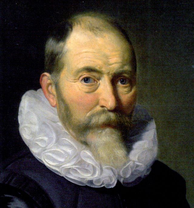
Willem Blaeu was a Dutch cartographer, globe maker, atlas publisher, and printer whose work helped define the Dutch Golden Age of mapmaking. He built a business in Amsterdam that produced nautical charts, wall maps, celestial globes, and luxurious atlases, combining scientific observation with ambitious design and fine printing.
| Born | 1571, Alkmaar, Dutch Republic |
|---|---|
| Died | 21 October 1638, Amsterdam, Dutch Republic |
| Field | Cartography, globe making, atlas publishing, printing |
| Known for | High-quality maps and atlases, especially the Atlas Novus and lavish printed world maps |
| Workshop | Blaeu’s Amsterdam printing and publishing house |
Who was Willem Blaeu?
Willem Blaeu trained in a period when mapmaking sat at the intersection of navigation, trade, astronomy, engraving, and publishing. He studied with the astronomer Tycho Brahe in Denmark, an experience that shaped his interest in precise measurements and instruments. After returning to the Dutch Republic, he established himself first as a maker of globes and scientific instruments and then as one of the most influential map publishers in Europe.
He is often grouped with the major figures of Dutch cartography, but his importance comes from more than technical skill. Blaeu understood that maps could serve merchants, sailors, scholars, and collectors at once. His workshop produced practical charts for the sea and ornamental maps for libraries and state rooms, and it did so with an unusually high standard of engraving and print production.
What did Blaeu actually make?
Blaeu’s output ranged from small navigation tools to large decorative atlases. He published pilot books and sea charts for the North Sea and wider Atlantic routes, along with terrestrial and celestial globes that could stand in scholarly interiors or be used as teaching devices. His maps often used crisp lettering, clear coastlines, dense decorative borders, and elegant cartouches, making them useful objects that also worked as display pieces.
His workshop also developed the printed atlas as a luxury object. The Atlas Novus, begun in the 1630s and later expanded by his sons, gathered maps into multi-volume sets that set a new standard for scale and ambition. Blaeu’s press was known for copperplate engraving, a process that allowed fine lines, shaded relief, and richly detailed ornament. This made his books expensive to produce, but also visually distinctive and widely admired.
Why does Willem Blaeu matter in design history?
Blaeu helped turn cartography into a prestige form of print design. In the Dutch Republic, trade and shipping created demand for accurate geographic information, but the market also rewarded elegance. Blaeu’s maps show how utility and visual persuasion could work together: coastlines had to be legible, yet the page also needed to signal authority, wealth, and trust.
His work influenced later mapmakers and publishers, including his own family business. After his death in 1638, the firm continued under his descendants, and the Blaeu name remained associated with excellence in atlas production. The maps and globes from his workshop now appear in museum collections and rare-book libraries as examples of how early modern print could organize knowledge through both data and design.
How were Blaeu’s maps and atlases made?
The making process began with gathering geographic information from sailors, surveyors, previous maps, and textual sources. Designers then translated that information into a copperplate engraving, where the image was cut in reverse into metal. The plate was inked and printed on paper, and the sheets were often hand-colored afterward, especially when a client wanted a more lavish finish.
Because he also sold globes and instruments, Blaeu worked across several related crafts. Printing required paper, inks, presses, and skilled pressworkers; engraving required precise line work; globe making required printed gores mounted onto spheres. The result was not just a set of images but a coordinated publishing operation in which science, trade, and craftsmanship reinforced one another.
Frequently Asked Questions
Was Willem Blaeu a scientist or an artist?
He was both, but his core identity was as a publisher and maker of geographical knowledge. His work depended on astronomical observation and mathematical accuracy, yet it also relied on engraving, page layout, and visual presentation. That combination made his output especially influential in an age when maps had to convince as well as inform.
What is the difference between Blaeu and Joan Blaeu?
Willem Blaeu was the father; Joan Blaeu was his son and business successor. Joan expanded the firm after Willem’s death and carried the Blaeu name into even larger atlas projects. Many works associated with the Blaeu workshop span both generations, so the family business often matters as much as the individual.
Why are Blaeu maps still collected?
Collectors value them for their craftsmanship, historical importance, and graphic beauty. They show the reach of Dutch commerce, the state of geographic knowledge in the seventeenth century, and the refined standards of copperplate printing. Many survive as prized objects because they were originally made for elite buyers who kept them carefully bound or framed.
Articles mentioning Willem Blaeu
