Reykjavík is the capital and largest city in Iceland, and the northernmost capital of a sovereign state. It sits on the southwest coast on the southern shore of Faxaflói Bay, where the urban area meets open water, lava fields, and a horizon shaped by volcanoes and weather. The city is both a government centre and the main hub for Icelandic commerce, culture, and daily life.
| Country | Iceland |
|---|---|
| Region | Southwestern Iceland |
| Founded as a town | 1786 |
| Population | About 120,000 in the city; over 200,000 in the greater area |
| Known for | National government, harbour life, design culture, access to volcanic landscapes |
Why Reykjavík matters
Reykjavík matters because it concentrates Iceland’s institutions in a place that still feels small and legible. Parliament, ministries, museums, studios, port facilities, and schools sit within a compact urban footprint. That scale shapes the city’s visual culture: street life, storefronts, and public buildings often feel modest rather than monumental, with an emphasis on function, daylight, and weatherproof materials.
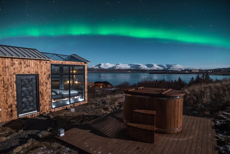
For photographers and image-makers, Reykjavík also acts as a threshold. It is often the starting point for journeys to lava fields, geothermal sites, glaciers, and coastal roads, but the city itself carries the same stark climate and light conditions that draw attention to Icelandic landscapes. In practice, that means low winter sun, long summer evenings, strong wind, and quick changes in weather all become part of how the city looks.
What does Reykjavík look like?
The city’s built form mixes older timber buildings, corrugated metal cladding, concrete civic structures, and newer glass-fronted hotels and apartments. Colour is used with intent. Bright painted facades break up long stretches of grey sky, while roofs and walls often rely on materials that can take rain, salt air, and freezing temperatures. The result is an urban texture that feels practical but not plain.
Reykjavík’s harbour area and central streets show how closely the city is tied to the sea. Fishing, shipping, tourism, and small-scale manufacturing have all left their mark on the waterfront. Even in newer districts, the presence of windbreaks, paved open space, and low-rise building profiles reflects the local climate more than any desire for grandeur.
How did Reykjavík develop?
Settlement around the site began in the 9th century, but Reykjavík grew slowly for centuries. The modern town was formally established in 1786, when Icelandic trade was reorganised under Danish rule. Its rise to capital status followed in the 20th century, when the city became the centre of a self-governing Iceland and later of the independent republic founded in 1944.
That history helps explain the city’s layered appearance. Reykjavík does not read like an old imperial capital with dense stone boulevards. It grew into its role through administration, fishing, education, and trade, and much of the urban fabric still reflects that pragmatic development. The city’s identity comes less from inherited monumentality than from adaptation to place.
Why is Reykjavík so often used as a base for Iceland photography?
Reykjavík gives photographers access to almost everything that defines Iceland’s public image. Day trips can reach volcanic landscapes, geothermal bathing sites, black-sand beaches, and open coastal roads. At the same time, the city offers a distinct urban subject: reflections in wet streets, winter darkness, lit windows in small houses, and harbour scenes under low cloud.
Its practical infrastructure also matters. Reykjavík has hotels, galleries, studios, equipment suppliers, transport links, and editing spaces, so it supports both travel photography and local visual work. Many published Iceland projects move between the city and the surrounding terrain because Reykjavík provides the human scale that makes the wider landscape more readable.
Frequently Asked Questions
Is Reykjavík a large city by global standards?
No. Reykjavík is small compared with most capital cities, with roughly 120,000 residents in the city and a little over 200,000 in the wider metropolitan area. Its importance comes from its role as the national centre, not from size. That modest scale is part of its character and part of its appeal.
Why is Reykjavík described as the northernmost capital?
Reykjavík sits at about 64°08′ north latitude, farther north than any other capital of a sovereign state. That location gives it long summer days, very short winter daylight, and a climate shaped by the North Atlantic. Those conditions affect everything from architecture to photography.
What industries and activities define the city?
Government, tourism, finance, education, creative work, and harbour-related activity all matter in Reykjavík. The city is also central to Iceland’s cultural life, with museums, music venues, galleries, and design businesses concentrated there. Its economy and image are both closely tied to the surrounding sea and landscape.
At a glance
- Address
- Reykjavíkurborg, Iceland
- Coordinates
- 64.13333, -21.933332
Articles mentioning Reykjavík